Chapter 11 | Controlling the Use of Private Land through Zoning
Overview
Local governments use zoning to regulate the use of land, the intensity or density of that use, and the allowable dimensions of buildings place on a particular site. The chapter introduces the idea of dividing the community into zoning districts, with the rules for the use and development of land varying by district. It also discusses the sometimes rigid design implications of traditional zoning. The chapter discusses the zoning map and introduces the topics of rezoning, variances and uses by review. Finally it discusses contemporary efforts at zoning reform.
Weblinks from Chapter
Exercises
Note: There are many exercises suggested here, all laying a foundation for the discussion question. In a class setting, it may make sense to break into small groups, with each group taking one or two of the exercises and then sharing the results with the class as a basis for the discussion.
- Get a copy of the zoning map for your community. At the publication date of this edition, some communities have zoning maps available on-line, but many are still maintained in offices. The technology of putting text-based zoning ordinances on-line is much simpler than the technology of putting complex, frequently changed maps on-line (but see discussion of Geographic Information Systems in chapter 4. You may need to go to the planning office to obtain a copy of the map. If you live in a large community where the zoning map comes in sections, get maps of three or four sections with which you are familiar, including some developed areas and some developing ones. Compare the zoning map to the future land-use map from the comprehensive plan. How well do they match in developed areas? How well do they match in developing ones?
- Find your house or some residential area with which you are familiar on the zoning map. Look up the zoning rules for that district. What other uses are allowed there? Are any uses by review allowed? Are you surprised by any of the uses that are permitted?
- Look through the zoning ordinance for your community and determine in what districts you could establish the following: a bowling alley; an adult bookstore; a bar; a movie theater; a church that seats three thousand people and may show movies in its auditorium on weeknights; a homeless shelter; a video rental store. Now find locations on the zoning map(s) where you could establish these uses. Are these logical locations for these uses? Why or why not?
- Attend a meeting of the zoning board of adjustment or board of appeals and watch that body in action. Do the members grant variances just to alleviate hardships, or do they follow other criteria? Check the zoning ordinance—are those criteria in the zoning ordinance?
- Attend a meeting of the planning commission when it is considering one or more applications for rezoning. Do commission members seem concerned with the comprehensive plan? Does their recommendation in each case seem to conform to the comprehensive plan?
- Although this makes a lot of meetings, try to attend the meeting of the governing body at which they consider the cases that you saw before the planning commission. If you call the clerk’s office, you may be able to determine what time they are likely to consider the zoning matters. Do the members of this body seem concerned with following the comprehensive plan? Do they do so?
- Find the commercial district that applies to the area that you consider downtown. Do the rules for that district resemble the current development? Do they require off-street parking? Do they require building setbacks? Do they allow people to live above stores? Do you think that the rules that apply to your downtown make sense?
Class Discussion Exercise
- Consider the results of the exercises above. Could you, as a class, recommend some improvements to the local zoning ordinance? Do those conform to the plan? Do you want to recommend some improvements to the plan, also?
Examples
See “supplemental resources.” The best examples will be local ones, which can be found through resources provided there.
For some interesting examples, see the following:
- Shortly after the turn of the new century, Chicago spent five years developing a new zoning ordinance, tailored to the current urban character and urban form. The city’s website provides links to the code and online zoning maps.
- Snohomish County, Washington, has an extremely user-friendly, interactive zoning map that allows the user to look at aerial photographs and some environmental data, as well as zoning information.
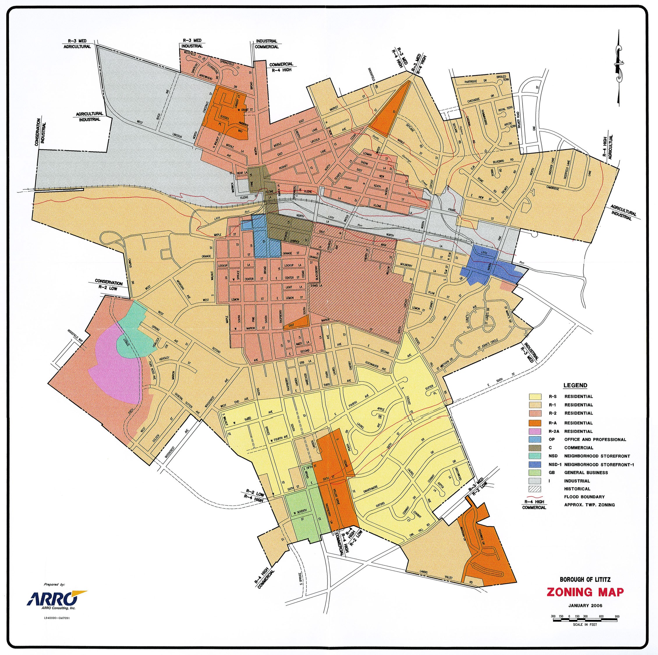
- For a simple zoning map for a small community, see the one for Lititz, Pennsylvania.
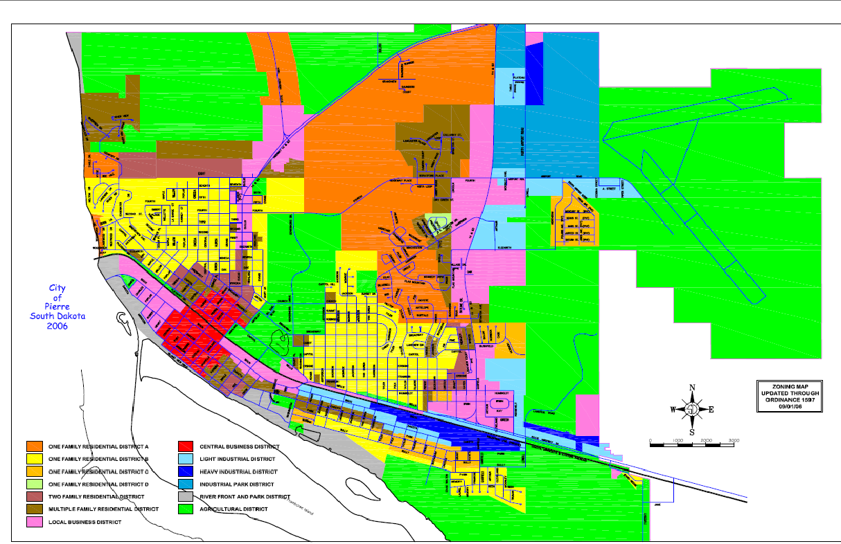
- For a map for a small city in the Midwest, see the one for Pierre, South Dakota.
- The State of Utah has put many local zoning ordinances from that state online in one location.
- Pflugerville, Texas maintains a section of its website for notices of public hearings on zoning matters.
Supplemental Resources
Zoning Ordinances
Many local zoning and other land-use ordinances are available electronically. Some are provided as PDF documents or interactive websites on the local government home page. Many others, however, are included as part of the “codes of ordinances” of the local governments; those codes include not only zoning and subdivision ordinances, but additional local ordinances dealing with everything from animal control to waterways. A large percentage of local codes are maintained on websites maintained by national code services; the electronic versions of the local codes are almost always available for free. Here is a list of the major providers:
- Municipal Code Corporation; click on “on-line library” (this is the most truly national code company, with codes from across the country; it is particularly popular with local governments in the southeastern states).
- General Code Corporation; General Code is particularly popular in the Midwestern and mid-Atlantic states, but it also includes codes from Wyoming
- LEXIS-NEXIS Municipal Codes Library; this service has a large number of local codes from California and from some other western states, but it has individual codes from a total of 24 states.
- American Legal Publishing Code Library.
Note that zoning maps are not available from the code companies; see discussion below.
Zoning Maps
Many zoning maps are also available on-line, although there are fewer zoning maps available on-line than there are zoning codes. Zoning maps are available only from local government websites, not from the national code companies. A local zoning map may be available in a PDF or other easy-to-download format; where such documents are available, they are usually under the planning, community development, growth management or similar department. If “zoning map” does not show up as a subheading, look for “maps” or “map atlas.”
Some local governments have zoning layers for their Geographic Information Systems (GIS); look at the menu for the GIS system and see if zoning is available. Not all GIS systems have a zoning layer.
If you cannot find the zoning map on-line, you may need to go to the planning department or similar office to ask to see the map. A small community may have a single zoning map posted on the wall of the planning office and/or in the meeting room used by the planning commission. Some communities have zoning maps in a form that can be readily reproduced (usually at a small cost for the copy) so that you can take a copy with you. In larger communities, the zoning map is likely to be broken into multiple parts, maintained in a “zoning atlas” – a book containing many sheets of maps showing zoning for different parts of the community.
Other
For a humorous (but largely factual) look at changes affecting the retail industry in 2009 and 2010, see the website Dead Malls.
Common Search Terms
Use these terms in search engines to find additional examples and other resources:
Zoning, zoning map, zoning ordinance, zoning variance, rezoning, zoning map amendment